- Yousmarg is a hill station in the western part of Kashmir Valley in the Indian state of Jammu and Kashmir. It is situated 47 km south of Srinagar the capital of the state.
- Yousmarg
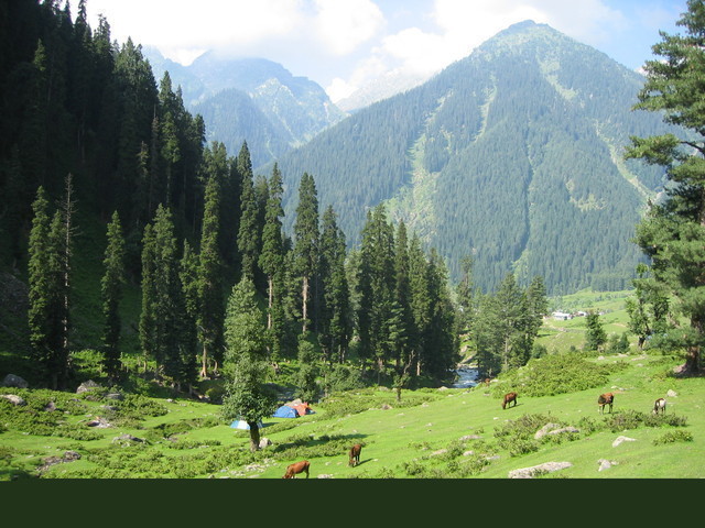
has a great scope for adventure tourism. Doodganga a river flows through this
meadow. In its vicinity lies the alpine meadow of Tosa Maidan. A trek of 4 km
leads to a small Lake named as Nilnag surrounded by pine trees. Another
10 km trek leads to the most interesting lake the frozen lake in
Sang-e-Safed valley, most portion of this lake is covered by ice even during
the summer. A number of tourist huts, restaurants and hotels are available for
lodging. The other activities include horse riding, fishing, skiing during
winter and photography.

Friday, August 30, 2013
Yousmarg

Verinag
- Verinag spring which is in Verinag town issues from a high scarp of a mountain spur, and is considered the source of the river Jhelum. It is situated at the bottom of a hill covered by pine trees and evergreen plants. The Mughal Emperor Jehangir constructed an octagonal tank of sculptured stones around the spring for which carvers for were brought from Iran. A garden was also built by Jahangir next to this natural spring which is of pre-Islamic religious significance. The construction date of the octagonal tank and the garden is 1029 Hijri or 1620 A.D. is duly inscribed on a stone slab built into the southern wall of the spring. The water is collected in a pool surrounded by arched recesses, and then flows down a 300-yard canal to the Bihat river. Jahangir wished to be buried at Verinag gardens, but his wife, Nur Jahan, disobeyed his wishes. Today nothing remains of the pavilions which once decorated the area. According to a legend, goddess Vitasta(Jhelum) wanted to take rise from this place, but it happened that when she came, Shiva was staying here, whereupon she had to go back and then she took her rise from Veravurthur, a spring about a mile to the north-west of this place. Virah in Sanskrit means to 'go back' and 'nag' means a water spring and, as Vitasta had to go back from this place, it came to be called Virahnag or "Vernag".
- Verinag spring was originally an irregular and shapeless pond, and water, oozing out from different places in it and spread about and formed a little marsh. The emperor Jahangir, whose artistic taste for polishing the beauty of nature is well known, saw this and at once determined to improve it. He built the octagonal tank of sculptured stones round it, so that all water was collected therein. The construction of water garden and the octagonal tank around the spring at Verinag was completed in the year 1620 A.D. or 1029 Hijri during the 15th year of the Jahangir's reign. Seven years later, Jahangir's son Shah Jahan, who was no less a lover of natural beauty, constructed cascades and aqueducts in straight lines through and around the fine garden which he, in order to enhance further the beauty of the place laid out in front of the spring. He also built hot and cold baths to the east of this garden, just outside of it, of which little trace is now left. The spring is the main source of the mighty river Jhelum. The water contained in an octagonal spring has crystal blue water in which a variety of big fishes live. History and the carvings on stones in Persian on the walls surrounding the spring tell about how this great source of underwater spring is contained without revealing its architecture.
- The spring is at the exact centre almost 50 feet (as the locals tell about the depth) under water from where the water continuously comes up and flows into the gardens facing the spring. It is also a sacred place for Hindus as there is a Lord Shiva shivling in one of the arcs (the very first on the left of the entry of the spring). The historical garden also has an old temple with some ancient idols of Hindu goddesses.
- Some 2 km away is Veravurthur, supposed to be the source of the Jhelum.
The waters of the many nearby springs, called collectively, Sapta Rishi, have
their confluence at Sangam, where people bathe on festival days. The birth of
the river is celebrated annually with a fair.


Tangmarg
- Tangmarg has many tourist spots like Drung, Gulmarg, Baderkoot, Zandpal, Gogaldara, Nigli Nullah and Babarashi. The name 'Babarashi' is based on Baba Payamum-din-Rashi whose body is buried here.
- It is a major stop for buses and other heavy vehicles between Srinagar and Gulmarg or Babareshi. All the vehicles are allowed beyond this point to Gulmarg which is 13 km[citation needed]. Heavy vehicles are not allowed beyond this point during the winter whenever there is a heavy snowfall. This stop is to be taken seriously since there are no more stores on the way to Gulmarg from Tangmarg. A road from Tangmarg to Gogaldara is under construction.
- This road would connect
Tehsil Tangmarg with Tehsil Khag of Badgam district. Another road from Drung to
Poonch district of Jammu Division is under consideration by the government.

Srinagar
- Srinagar is the summer capital of the Indian-held Jammu and Kashmir. It is situated in the Kashmir Valley and lies on the banks of the Jhelum River, a tributary of the Indus. The city is famous for its gardens, lakes and houseboats. It is also known for traditional Kashmiri handicrafts and dry fruits.


Sonamarg
- Sonamarg gives rise to The Three Sisters (Kashmir). In its vicinity lies the great Himalayan glaciers of Kashmir Valley namely Kolhoi Glacier and Machoi Glacier with some peaks of above 5000 meters: Sirbal Peak, Kolhoi Peak, Amarnath Peak and Machoi Peak.
- Sonamarg an alpine valley is situated at the bank of Nallah Sindh, 87 km north-east from Srinagar, it is a popular tourist destination, nestled with in the imposing Himalayan peaks. It lies at an altitude of 2800 metres above sea level.
- The drive to Sonamarg is through yet another spectacular facet of country
side in Kashmir, this time its the Nallah Sindh, the largest tributary of the
Jehlum River in the valley of Kashmir. It is upwards of sixty miles long valley
and deep rock-girt gorge to open grassy meadow land and village-dotted slopes.


Sanasar
- Sanasar lake, 20 km from Patnitop by road, offers paragliding,
camping, trekking, abseiling, rock climbing and scenic nature walks.


Patnitop
- Patnitop or Patni Top is a hilltop tourist location in Udhampur district in Jammu and Kashmir state of India on National Highway 1A 112 km from Jammu on the way from Udhampur to Srinagar. Situated on a plateau in the Shiwalik belt of the Himalayas, Patnitop sits at an altitude of 2,024 m (6,640 ft). The river Chenab flows in close proximity to this location.
- The name 'Patnitop' is a distortion of the original name of the place, "Patan Da Talab" meaning "Pond of the Princess". In olden times a pond existed in the meadows and a certain princess often used to bathe there. Some part of the pond still exists near the local youth hostel. It may be the case that the British had difficulties recording the Indian name correctly in their revenue records. Hence, over the years the name has changed from "Patan Da Talab" to Patnitop.
- One can enjoy the thrill of flying, at Patnitop. The paragliding joyrides rides are conducted at Dawariyai, 2 km landmark, on the Patnitop-Sanasar road. One can ask for paragliding at the Patnitop Development Authority (PDA) barrier.
- The takeoff site is at Dawariyai, on the Patnitop-Sanasar road. The area often called as the Billoo Di Powri point. Approx 400 plus steps have been carved out along the rock face to make the steep slope negotiable. The stairs eventually leading to Dawariyai, the "gateway". The exact dating of the work is still debatable. Any tourist can experience paragliding accompanied by a pilot. The flight takes off from Patnitop and lands at Kud. The flight lasts for 7 to 15 minutes depending upon the wind conditions. One is retrieved by car to the takeoff area. The organizers also give a good quality video of the memorable flight.
- Takeoff is from Natha Top and landing at Kud. The flight can be
from 15 minutes to an hour depending on the wind conditions.


Pahalgam
- Pahalgam is a town and a Municipal committee in Anantnag district in India's northernmost state of Jammu and Kashmir. It is a popular tourist destination, and every year, many tourists visit Pahalgam. This world famous hill station is 45 km. from the District Head Quarter at Anantnag and located on the banks of river Lidder at an altitude of 7200 ft. from sea level. Pahalgam is one among the five tehsils of Anantnag district and tehsil head quarters are located in the main town of Pahalgam. It was once a tourist attraction and a favourite place for shooting of Bollywood films, and is still a health resort. Besides tourist huts, several hotels in private sector have come up here and these hotels provide modern facilities to their guests. A number of treks in this region also begin from Pahalgam, as the 35 km trail traverses through pinewoods to the spectacular Kolahoi Glacier.
- Pahalgam is also associated with the annual Amarnath Yatra. Chandanwari (2,895 m), 16 km from Pahalgam, is the starting point of the yatra that takes place every year in the month of Sawan (July to August). The road from Pahalgam to Chandanwari is on fairly flat terrain and can be undertaken by car. From Chandanwari onwards the track becomes much steeper, and is accessible on foot or by pony. About 11 km from Chandanwari is the mountain lake of Sheshnag (3,574 m), after which, 13 km away is the last stop, Panchtarni. The Amarnath cave is 6 km away from there. During the month of Sawan, an ice stalagmite forms a natural Shivling in the Amarnath cave.
- Kolohoi Glacier, situated up the Lidder Valley, just below Kolhoi Peak is currently a hanging glacier. It is accessible from Pahalgam via Aru. It is known to have extended for at least 35 km in the past. It is basically hollowed out from global warming, the Asian brown cloud, and local environmental factors associated with mountain hydrology. According to the mountaineers from Jawahar Institute of Mountaineering (JIM) in 2008, the glacier has receded by half since 1985. The glacier is not safe to study because it is hollow and in places has 200-foot-deep (61 m) crevices.
- Betaab Valley is a very famous tourist spot situated at a distance of 15
kilometers from Pahalgam. The valley got its name from the Sunny Deol-Amrita
Singh hit debut film Betaab. The Valley is towards northeast of Pahalgam and
falls between Pahalgam and Chandanwadi and is en route Amarnath Temple Yatra.
The valley surrounded by lush green meadows, snow clad mountains and covered
with dense vegetation.


Manasbal Lake
- Manasbal Lake is a lake located in Safapora area of Ganderbal District in the State of Jammu and Kashmir in India. The name Manasbal is said to be a derivative of the Lake Manasarovar. Lake is encircled by three villages viz., Jarokbal, Kondabal (also called Kiln place, is situated on the north-eastern side of the lake) and Ganderbal and is stated to be the deepest lake (at 13 m or 43 ft depth) in India. The large growth of lotus (Nelumbo nucifera) at the periphery of the lake (blooms during July and August) adds to the beauty of the clear waters of the lake. The Mughal garden, called the Garoka, (meaning bay window) built by Nur Jahan overlooks the lake.
- The lake is a good place for birdwatching as it is one of the largest natural stamping grounds of Aquatic birds in Kashmir and has the sobriquet of "supreme gem of all Kashmir Lakes". The rootstocks of lotus plant which grows extensively in the lake are harvested and marketed, and also eaten by the local people.


Mansar Lake
- Mansar Lake is situated 62 km (39 mi) from Jammu, Mansar is a beautiful lake fringed by forest-covered hills, over a mile in length by half-a-mile in width.
- Besides being a popular excursion destination in Jammu, it is also a holy site, sharing the legend and sanctity of Lake Mansarovar. On the Eastern Bank of the Lake there is a shrine to Sheshnag, a mythological snake with six heads. The shrine comprises a big boulder on which are placed a number of iron chains perhaps representing the small serpents waiting on the tutelary deity of the Sheshnag. Two ancient temples of Umapati Mahadev & Narsimha as also a temple of Durga are situated in the vicinity of the Mansar lake. People take a holy dip in the water of the lake on festive occasions.
- Newlyweds consider it auspicious to perform three circum-ambulations (Parikarma) around the lake to seek the blessings of Sheshnag, the lord of serpents, whose shrine is located on its eastern bank.
- Certain communities of Hindus perform the Mundan ceremony (First hair cut) of their male children here.
- There are also some ancient temples on the lake’s shores, which are visited by devotees in large numbers. Mansar is also ideal for boating for which the Tourism Department provides adequate facilities.
- With all religions belief and heritage behind the Mansar Lake is also picking up its fame among the tourists with all its flora & fauna. The lake has cemented path all around with required illumination, with projected view decks to enjoy flickering of seasonal birds, tortoise and fishes of different species. There is a wild life Sanctuary housing jungle life like Spotted Deer, Neelgai etc. besides other water birds such as Cranes, Ducks etc. One can also witness the traditional and typical distinct life style of Gujjar and Backarwals wearing ethnic costume, living in open Kullhas around on the hills of Mansar Lake.
- This Mansar lake road joins to another important road that directly links Pathankot (Punjab) to Udhampur (Jammu & Kashmir, Jammu Province. Udhampur is a Town of strategic importance, again on National Highway No. 1A. The shortcut road from Mansar or Samba to Udhampur by-passes the Jammu town. Surinsar Lake, a smaller lake that is linked to Mansar, is 24 km (15 mi) from Jammu (via a bypass road).


Mammer-a
- Mammer-a is a Village in Kangan Tehsil in Ganderbal District of Jammu & Kashmir State, India. It is located 16 KM towards East from District head quarters Ganderbal. 25 KM from State capital Srinagar, Jammu.
- Mammer-a is surrounded by Ganderbal Tehsil towards west , Sumbal Tehsil towards East , Gurez Tehsil towards North , Lar Tehsil towards west. Srinagar , Bandipore , Sopore , Baramula are the nearby Cities to Mammer-a.
- This Place is in the border of the Ganderbal District and Srinagar District. Srinagar District Srinagar is South towards this place . Also it is in the Border of other district Bandipora.


Kud
- It is located on the Udhampur Srinagar Highway.100 k.m from Jammu and 34 k.m from Udhampur city, it is just short of the tourist spot of Patni Top while driving to Patni top from Udhampur. After Patnitop is the adjoining town of Batote.
- Kud is famous for its sweet shop that makes hot and fresh patisa that is very popular with the tourists.


Katra
- Katra or Katra Vaishno Devi, as it is popularly known, is a small town in Reasi district of the Indian state of Jammu and Kashmir situated in the foothills of the Trikuta Mountains, where the holy shrine of Vaishno Devi is located. It is located 42 km from the city of Jammu. Shri Mata Vaishno Devi University, one of the leading technical universities of India, is also located here.
- Katra serves as the base camp for pilgrims who visit Vaishno Devi. It has a thriving tourism industry that offers plenty of hotels, guest houses, restaurants, dhabas, fast-food joints that fit all kinds of budgets. Free accommodation is provided by some registered trusts in the form of Sarais for the poor. The number of pilgrims that visit the shrine every year has increased from 1.4 million in 1986 to 8.2 million in 2009. Over the years, a lot has changed, but one should not miss the opportunity to walk through the main bazaar (market) for buying (do not forget/hesitate to negotiate a bit) souvenirs, dryfruits, woolen garments, hosiery, leather jackets, etc.
- To reach Vaishno Devi temple the pilgrims have to register at the Katra before starting the trek. By registering, the pilgrims get accidental insurance while on the trek for 1 lakh INR. It is a trek of 10.5 km.
- There is another trek (1.5 km) from Vaishno Devi temple for Baba Bhaironnath. It is said that the pilgrimage is not complete until you visit this temple at last. The scenery throughout the trek is picturesque.
- Environment-friendly auto rickshaws and helicopter services also have started now-a-days to make the journey a pleasant one.


Jammu
- It is the largest city in the Jammu region and the winter capital of Indian administered state of Jammu and Kashmir and situated on the banks of Tawi river. It is a municipal corporation. Jammu is also known as the City of Temples owing to the number of historical temples and domes of old mosques located within the city. With its fastest growing urban agglomerations and booming infrastructure the winter capital of state is the second largest city in the state.
- Jammu city lies at uneven ridges of low heights at the Shivalik hills. It is surrounded by Shivalik range to the north, east and southeast while the Trikuta Range surrounds it in the north-west. It is approximately 600 kilometres (370 mi) from the national capital, New Delhi.
- The city spreads around the Tawi river with the old city overlooking it from the north (right bank) while the new neighbourhoods spread around the southern side (left bank) of river. There are four bridges on the river. The fifth bridge on the Tawi river is under construction and would be ready soon. The city is not flat. One part is high and other is low and the city spreads on these uneven ridges of very low heights. The Bahu hill and the old city spread on each bank of Tawi are the highest points with the royal Dogra Palace at another height overlooking it. The airport is situated at Satwari.
- Bahu Fort, which also serves as a religious temple, is situated about 5 km from Jammu city on a rock face on the left bank of the river Tawi. This is perhaps the oldest fort and edifice in Jammu city. Constructed originally by Raja Bahulochan over 300 years ago, the fort was improved and rebuilt by Dogra rulers. Inside the fort, there is a temple dedicated to the Goddess Kali, popularly known as Bave Wali Mata, the presiding deity of Jammu. Every Tuesday and Sunday pilgrims throng this temple and partake in "Tawi flowing worship". Today the fort is surrounded with a beautiful terraced garden which is a favourite picnic spot of the city folk. Bagh-E-Bahu located on the banks of Tawi river, is a Mughal-age garden. It gives a nice view of the old city and Tawi river. Bagh itself is very beautiful. There is a small cafeteria on one side of the garden. On the by-pass road behind Bahu Fort, the city forest surrounds the ancient Mahamaya Temple overlooking the river Tawi. A small garden surrounded by acres of woods provides a commanding view of the city. Opposite the Bahu Fort, overlooking the River Tawi is a temple dedicated to Mahamaya of Dogra decent, who lost her life fourteen centuries ago fighting foreign invaders. The present temple of Bawey Wali Mata was built shortly after the coronation of Maharaja Gulab Singh, in 1849. It is also known as the temple of Mahakali and the goddess is considered second only to Mata Vaishno Devi in terms of mystical power.

- Amongst the temples in Jammu, the Raghunath Temple takes pride of place being situated right in the heart of the city. This temple is situated at the city center and was built in 1857. Work on the temple was started by Maharaja Gulab Singh, founder of the Kingdom of Jammu and Kashmir, in 1835 AD and was completed by his son Maharaja Ranbir Singh in 1860 AD. The inner walls of the main temple are covered with gold sheet on three sides. There are many galleries with lakhs of saligrams. The surrounding Temples are dedicated to various Gods and Goddesses connected with the epic Ramayana. This temple consists of seven shrines, each with a tower of its own. It is the largest temple complex in northern India. Though 130 years old, the complex is remarkable for sacred scriptures, one of the richest collections of ancient texts and manuscripts in its library. Its arches, surface and niches are undoubtedly influenced by Mughal architecture while the interiors of the temple are plated with gold. The main sanctuary is dedicated to Lord Vishnu's eighth incarnation and Dogras' patron deity, the Rama. It also houses a Sanskrit Library containing rare Sanskrit manuscripts.

- Alongside the same Tawi river are the Peer Kho Cave temple, the Panchbakhtar temple and the Ranbireshwar temple dedicated to Lord Shiva with their own legends and specific days of worship. Peer Kho cave is located on the bank of river Tawi and it is widely believed that Ramayan character Jamvant (the bear god) meditated in this cave. The Ranbireshwar Temple has twelve Shiva lingams of crystal measuring 12" to 18" and galleries with thousands of saligrams fixed on stone slabs. Located on the Shalimar Road near the New Secretariat, and built by Maharaja Ranbir Singh in 1883 AD. It has one central lingam measuring seven and a half feet height (2.3 m) and twelve Shiva lingams of crystal measuring from 15 cm to 38 cm and galleries with thousands of Shiva lingams fixed on stone slabs.


Daksumgulmarg
- As you drive past the Mughal Gardens of Achabal, you will come across the picturesque Daksum. Situated amidst the magnificent grandeur of the Kokarnag springs, it presents an awe-inspiring sight. Standing at an altitude of 2438 m in a densely forested gorge, Daksum offers peace and tranquility. The only sound heard there is that of the Bringhi River, rushing right through its center. Daksum in Kashmir valley is a must for those fond of walking and nature.
- A walk in Daksum will take you up to the hills enveloped in lush coniferous trees and past gurgling brooks. The simple music coming out of the flute of an unseen shepherd tending to his flock will keep you mesmerized. The landscape of Daksum is quite erratic.
- From the tree-covered hills, you will suddenly find yourself in grassy meadows serving as host to the sheep coming for pasture. The invigorating mountain air, the calm and serenity, the densely clad hills, all make the trip to Daksum a memorable experience.
- Then, there are the snow-capped mountains in the background that further enhance the beauty of this place.


Batote
- Batote is a town and a notified area committee in Doda District.
- It is located on the National Highway from Jammu to Srinagar.It is 123km from Jammu towards Srinagar. National highway 1B(To Doda)also originates from batote. While driving from Jammu it comes after passing Udhampur, Kud and a famous tourist spot Patni Top.
- There is a sharp descent road to Batote from Patnitop. Batote is very famous for its beauty and weather. Many peoples come here to spent their summer vaccation and enjoy its cool and pleasant weather. Some agricultural land also there in the vicinity of batote town.
- Some famous places of Batote are Baghu Nallah, Tringla , Boon Badi etc. Baghu Nallah is famous for its Gurudwara in the memory of great saints of Jammu and Kashmir Sant Mela Singh and Sant Rocha Singh .Every year large no of devotees come here to celebrate annual function in the memory of those great saints.
- The region is famous for its pleasant weather during summer and its all surrounded greenry.Besides the region is also famous for its high quality kidney beans or Rajma.


Banihal
- Banihal is a town and a notified area committee in Ramban district in the Indian state of Jammu and Kashmir. "Banihal" means blizzard in Kashmiri language.
- It has an average elevation of 1,666 m (5,466 ft). It is located about 35 km (22 mi) away from Qazigund of Anantnag district on NH 1A highway. However, the distance between Banihal and Qazigund is only 18 km by train on the new railway line which is much shorter than the road.
- Banihal Pass at 2,832 m (9,291 ft) elevation on Pir Panjal mountain connects Banihal with Qazigund on the other side of the mountain. The Pir Panjal mountain range separates the Kashmir valley in the Indian state Jammu and Kashmir from the outer Himalaya and plains to the south. After closure of the Murree-Muzaffarabad-Srinagar road on partition of India in 1947, Banihal pass was the only passage from Jammu to Srinagar after independence until 1956 when a tunnel was bored through the mountain. The pass is accessible only in summer and remains closed rest of the year due to heavy snow.


Aru
- Aru is a tourist spot in the Anantnag District of Jammu & Kashmir, India. It is located around 12 from Pahalgam, 11 km upstream from the Lidder River. Noted for its scenic meadows, lakes and mountains, it is a base camp for trekking to the Kolhoi Glacier and Tarsar Lake. The village lies of the left bank of the Aru river, which is a tributary of the Lidder river.
- The Aru valley is noted for its scenic meadows. It is popular among the tourists for its peaceful environment and scenic beauty.
- The village is a base camp for trekkers to the Kolahoi Glacier, the Tarsar-Marsar lakes and the Katrinag valley. It is also a base for the treks to Lidderwat, the Vishansar-Kishansar lakes and Kangan. The Kolahoi is the largest glacier in the Kashmir Valley, and is located near Mt. Kolahoi (5425m), the highest peak in the Valley. A number of hotels, restaurants and huts are available for boarding and lodging.
- There are about 20 alpine lakes, peaks and meadows around the Aru Valley. In the winters, when Aru receives heavy snowfall, skiing and heliskiing are practiced. Other popular tourist activities include fishing of trout in the Lidder river, trekking, hiking, horse riding, sightseeing and photography.
- The Overa-Aru Biosphere Reserve is located 76 km from the state capital Srinagar. It has the status of a Wildlife sanctuary, and is spread over an area of 511 sq.km. The altitude ranges from 3000–5425 m above the sea level.[citation needed] It is famous for several rare and endangered species.

Achabal
- Achabal is situated at a distance of 58 km from the district of Srinagar. Reached via Anantnag, Achabal served as the pleasure retreat of the Mughal Empress Nur Jehan. Situated at a height of 1,677 m, Achabal is a visual treat for the eyes. Achabal is adorned with one of the best Mughal Gardens in India.
- Resplendent in a history that dates back to the times of the Mughal rulers in India, much of the Kashmir Valley is scattered with gardens and palaces which are relics of the rich architectural heritage which we have inherited from the glorious rule of the Mughals in India.
- One of these is a garden built as a pleasure retreat of Empress Noor Jahan, the wife of Emperor Jahangir and one of the most charismatic empresses of the Mughal Era. A tour to Achabal is the perfect way to witness the charming Mughal architecture.
- Located at a height of 1,677 meters above sea level and around 58 kms away from Srinagar, a tour to Achabal is the perfect weekend getaway from Srinagar. Laid following the Persian style of gardening, one of the most popular styles of the Mughal era, the Garden is a riot of colors while sparkling waters gush out of exquisitely designed fountains.
- The garden which is built on the foot of a hill is surrounded by a spell binding array of tall Chinar trees, which add a special touch of regality to the still stately Mughal Gardens at Achabal. A tour to Achabal during autumn is made even more special when these Chinar Trees turn red, evoking images of beauty that remain with you ages after your holiday in Jammu and Kashmir is over!
- The easiest way of reaching Achabal is by air. The nearest airport is at the Badgam District around 58 kms away from the village of Achabal. The nearest railhead to Achabal is at Jammu from where it takes an approximate time of around 2 hours to reach Achabal.
- Achabal is well-connected to a number of other regions of Jammu and Kashmir. There are a number of well maintained roads which lead to Achabal.

Subscribe to:
Posts (Atom)